Six Airspace Classes: Chart Skills for Student and Drone Pilots
Six Airspace Classes: Chart Skills for Student and Drone Pilots
U.S. airspace splits into six classes: A, B, C, D, E, and G. Classes A through E are controlled, meaning air traffic control provides some level of separation or service. Class G is uncontrolled. The single most important rule to remember: Class A demands an IFR flight plan and ATC clearance with no exceptions, whereas every other class has its own mix of communication and clearance requirements that get less strict as you move down the alphabet toward G.
- Controlled airspace requires specific radio, transponder, and flight plan requirements, especially in Class B, C, and D, for legal entry and safety.
- Class A airspace, starting at 18,000 feet, mandates IFR flight plans and IFR-only operations with ADS-B Out, but is not depicted on sectional charts.
- Overlapping airspace layers always follow the strictest rules, so pilots should default to the more restrictive regulation when unsure.
- For drone operators, digital tools like SkyScore and operations software streamline airspace checks, but fundamental knowledge remains essential.
- Preflight planning should focus on understanding each airspace’s vertical limits and communication needs before consulting chart symbology.
Flydronable
Check Airspace Before You Fly
SkyScore helps drone pilots streamline airspace checks within Dronable’s unified workspace for more organized operations.
Table of Contents
- What Is an Airspace Class, and Why Does the Sky Get Divided?
- Controlled vs. Uncontrolled Airspace: What Actually Changes
- Class A: The IFR-Only Layer Above 18,000 Feet
- Class B: The Wedding Cake Around the Busiest Airports
- Class C: Two-Way Radio Contact and a Simpler Shape
- Class D: Towered Fields With a Simpler Bubble
- Class E: The Airspace That Fills in the Gaps
- Class G: The Default Uncontrolled Airspace
- Special Use Airspace: Restricted, Prohibited, and the Areas That Bite
- Reading Airspace on a Sectional or Terminal Chart
- When Airspace Classes Overlap: Which Rule Wins
- A Preflight and In-Flight Checklist for Student Pilots
- Applying Airspace Rules as a Working Drone Pilot
- Study Priorities That Actually Get You Checkride-Ready
- Checking Airspace Without the Guesswork
- Sources
What Is an Airspace Class, and Why Does the Sky Get Divided?
An airspace class is a designation that tells you what equipment you need, who you must talk to, and how much separation ATC provides in that piece of sky. The FAA groups U.S. airspace into six classes rather than treating the whole country as one uniform block, because traffic density and risk vary enormously from downtown Chicago to rural Montana.
The FAA weighs four factors when it draws these boundaries: how dense and complex traffic is in an area, the type of operations happening there (airline, general aviation, military), the level of safety required, and the national public interest at stake. A busy hub airport needs tighter control than a grass strip fifty miles from anywhere. That logic explains why Class B wraps around major airports like a tiered cake while Class G blankets huge stretches of open country.
Airspace also splits into regulatory and nonregulatory categories. Classes A through E are regulatory. Special-use areas, which you’ll read about later, can be either. Worth flagging early: the U.S. system skips Class F entirely. Some countries use it, but American charts never do. If you train or fly abroad, don’t assume the letters mean the same thing they do at home.
Controlled vs. Uncontrolled Airspace: What Actually Changes
Controlled airspace means ATC is watching and, in many cases, actively separating traffic. Uncontrolled airspace means you’re on your own for spacing, though you can still request advisory services if you want them. Classes A, B, C, D, and E are controlled. Class G is not.
That distinction changes three things in practice: what you carry, what you say, and how close other aircraft are legally allowed to get to you.
Equipment expectations climb as you move into busier controlled airspace. A two-way radio and a Mode C transponder or ADS-B Out become mandatory in and above most Class C and B airspace. Class G asks for none of that by regulation, though flying without a radio near a nontowered field is a bad habit even when it’s legal.
VFR weather minimums tighten the same way. In Class G below 1,200 feet AGL during the day, you can legally scrape by with just one mile of visibility and clear of clouds in some areas. Step into Class E and you’re generally looking at three miles visibility and specific cloud clearance distances.
Here’s the pattern worth memorizing before anything else:
- Class A demands an IFR clearance from ATC before you go near it.
- Class B, C, and D all require you to establish communication (and in B’s case, receive an explicit clearance) before entry.
- Class E usually needs nothing more than the radio call itself, unless it starts at the surface.
- Class G requires no clearance or radio call at all, though good pilots still make one at busy uncontrolled fields.
Pro Tip: Don’t confuse “talking to ATC” with “being separated by ATC.” In Class D, a controller might give you traffic advisories, but VFR-to-VFR separation isn’t guaranteed. Know which classes actually promise separation and which ones just promise information.
Class A: The IFR-Only Layer Above 18,000 Feet
Class A starts at 18,000 feet MSL and runs up through FL600, and every aircraft in it must be flying IFR. There’s no VFR option, no exception for a clear day, no way around filing a flight plan and getting a clearance. The FAA’s Pilot’s Handbook of Aeronautical Knowledge is explicit about this: Class A exists specifically to keep high-altitude traffic under full positive control, because at those speeds and altitudes, visual separation alone isn’t reliable.
For a student pilot working on a private certificate, flight training programs will rarely bring you into direct contact with Class A airspace. You won’t be filing flight plans into the flight levels during your checkride. But understanding it matters for two reasons. First, it explains why airliners cruise where they do. Second, it clarifies something that trips up new pilots looking at charts: Class A isn’t drawn on sectional charts at all. There’s no boundary line to find because it blankets the entire country at that altitude band. If you’re wondering why you can’t spot Class A on your chart, that’s the answer. It’s simply everywhere above 18,000 feet.
Equipment requirements match the seriousness of the airspace. You need an IFR-certified aircraft, an instrument rating, and a transponder with ADS-B Out. There’s no casual version of flying in Class A. Every aircraft up there is talking to ATC, following a clearance, and being actively separated.
Class B: The Wedding Cake Around the Busiest Airports
Class B airspace surrounds the nation’s busiest airports, and it typically runs from the surface up to the typical upper limit set around busy airports. The shape is famously described as a wedding cake because each layer widens as altitude increases, tailored individually to the traffic flow of that specific airport. Each Class B area has a unique configuration.
Getting into Class B is not optional or informal. You need an explicit ATC clearance, not just a radio call acknowledged by a controller. “Cleared into Class Bravo airspace” are words you’re listening for specifically. A controller saying “traffic in sight” or reading back your call sign doesn’t count as clearance.
A few practical points worth locking in before you fly anywhere near a Class B shelf:
- Every aircraft operating within Class B needs a two-way radio, a Mode C transponder or ADS-B Out, and (for most aircraft) a Mode C transponder specifically inside the surrounding mode C veil.
- Student pilots need specific endorsements to operate solo within certain named Class B areas, so check your logbook and training syllabus before planning a flight anywhere near one.
- VFR cloud clearance and visibility inside Class B require three miles visibility and staying clear of clouds, which is more forgiving than it sounds until you realize how much traffic is packed into that space.
- ATC sequences everyone in Class B, VFR and IFR alike, so expect vectors, altitude assignments, and speed adjustments even on a “just going flying” Saturday.
Busy Class B airports like Atlanta, Chicago O’Hare, or Los Angeles pack dozens of arrivals and departures per hour into that layered structure. The clearance requirement isn’t bureaucratic overkill. It’s what keeps a Cessna 172 and a departing 737 from occupying the same three-dimensional point in space.
Class C: Two-Way Radio Contact and a Simpler Shape
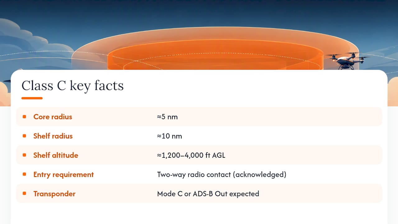
Class C airspace surrounds medium-sized airports with a control tower and radar approach control, and it follows a more predictable shape than Class B. The FAA’s standard layout puts a core surface area with roughly a 5 nautical mile radius under a shelf extending out to about 10 nautical miles, generally between 1,200 and 4,000 feet AGL.
The big procedural difference from Class B: you don’t need an explicit clearance into Class C. You need to establish two-way radio communication with ATC and hear your call sign acknowledged before you cross the boundary. That’s a real distinction, not a technicality. A controller saying “Cessna 1234 Alpha, standby” counts as establishing communication. A controller who never responds to your call does not, and you should not enter.
Once you’re inside, you keep talking. ATC provides traffic advisories and, in many cases, sequencing for arrivals, but the separation service is generally less absolute than what you get in Class B. Transponder requirements mirror Class B in most respects. You’ll want Mode C or ADS-B Out to operate in and above Class C airspace, and increasingly, ADS-B Out is the expectation nationwide.
Practically, Class C airports feel busier than Class D fields but calmer than a major Class B hub. Places like Sacramento or Wichita run Class C operations that see steady GA and regional airline traffic without the wall-to-wall intensity of a Class B mega-hub. If you’re training near one, expect controllers to be more forgiving of a slightly awkward radio call than they would be at a Class B tower, but don’t push your luck.
Class D: Towered Fields With a Simpler Bubble
Class D airspace surrounds airports with an operating control tower but no radar approach control, and it usually extends from the surface up to about 2,500 feet above the airport’s elevation. The shape gets custom-tailored around obstacles, nearby traffic patterns, and terrain, so don’t expect a clean circle every time.
Two-way radio contact is required before entry, same as Class C, but you don’t need to hear your call sign specifically acknowledged in every situation. The bigger thing to understand: VFR aircraft in Class D get traffic information from the tower, not guaranteed separation from other VFR traffic. That’s a meaningful gap in service level that catches new pilots off guard.
One quirk worth flagging specifically: some Class D airspace only exists part-time. When the tower closes for the night, that airspace typically reverts to Class E or Class G. Check the sectional chart’s notes and the airport’s hours of operation, because flying through what you assumed was Class D at 9 p.m. might actually mean flying through uncontrolled Class G instead, with no radio call required at all.
Class E: The Airspace That Fills in the Gaps
Class E is controlled airspace that doesn’t fit neatly into A, B, C, or D, and it shows up in more places than most new pilots expect. Base altitudes vary by location: some Class E starts right at the surface, some begins at 700 feet AGL, some at 1,200 feet AGL, and the widespread en route version starts at 14,500 feet MSL. It caps out at 18,000 feet MSL, right where Class A begins.
Several distinct flavors of Class E exist, and recognizing them on a chart matters:
- Surface-based Class E typically supports airports with an instrument approach but no operating tower.
- Extensions stretch outward from Class B, C, or D airspace to protect instrument approach and departure paths.
- Transition areas with 700-foot floors bridge the gap between surface airspace and the en route structure.
- Federal airways are 8-nautical-mile-wide corridors of Class E connecting navigation points across the country.
- En route domestic areas cover large sections of the country from 1,200 feet AGL up to but not including 18,000 feet MSL, per AIM guidance.
No radio call or clearance is required to enter most Class E airspace as a VFR pilot, which surprises students who assume “controlled” always means “you must talk to someone.” You’ll fly through Class E constantly on cross-country flights without ever keying the microphone for that reason alone. The catch is visibility and cloud clearance requirements tighten compared to Class G, so check the specific minimums before you plan a flight that skims low along a Class E floor.
Class G: The Default Uncontrolled Airspace
Class G is uncontrolled airspace, and it exists everywhere that isn’t claimed by A, B, C, D, or overlying Class E. It typically extends from the surface up to the base of the controlling Class E above it, whether that’s 700 feet, 1,200 feet, or higher depending on location.
No ATC separation exists in Class G. Nobody is watching your flight path and keeping other traffic away from you. VFR minimums are the loosest of any class: as little as one mile visibility and clear of clouds during the day below 1,200 feet AGL in many areas, though minimums tighten above that altitude and at night. That looseness is exactly why see-and-avoid discipline matters more here than anywhere else in the system.
Recreational pilots, agricultural operators, and a huge share of general aviation traffic spend most of their flight hours in Class G without ever touching a controlled boundary. Recreational drone flyers run into it constantly too, though FAA guidance for recreational fliers makes clear that “uncontrolled” doesn’t mean “unrestricted.” Nothing stops you from calling Flight Service or a nearby approach facility for traffic advisories in Class G. It’s optional, but smart pilots use it around busy uncontrolled fields.
Special Use Airspace: Restricted, Prohibited, and the Areas That Bite
Special use airspace overlays the six standard classes rather than replacing them, and it exists to warn or block pilots from areas with unusual hazards, military activity, or national security concerns. Getting this wrong isn’t a paperwork problem. It can mean flying through live ordnance ranges or restricted presidential airspace.
The categories worth knowing cold:
- Prohibited areas ban all flight, no exceptions, for security or safety reasons. Washington, D.C.'s P-56 is the textbook example.
- Restricted areas contain hazards like artillery fire or aerial gunnery, and you need authorization from the controlling agency to enter when the area is active.
- Military Operations Areas (MOAs) separate military training activity from IFR traffic. VFR pilots can legally fly through an active MOA, but doing so is asking for trouble given the speeds and maneuvers happening inside.
- Warning areas sit over international or coastal waters and warn of the same hazards restricted areas warn about, just outside domestic jurisdiction.
- Alert areas flag unusually high volumes of pilot training or unusual aerial activity, though all participants still follow standard right-of-way rules.
- Controlled firing areas (CFAs) are unique because activities stop entirely the moment a nonparticipating aircraft approaches, so the FAA doesn’t even chart them as a boundary you need to avoid.
Checking whether restricted airspace or an MOA is “hot” before you fly through it means calling the nearest Flight Service Station, checking NOTAMs, or reviewing the chart’s schedule notes. Temporary flight restrictions add another layer entirely, popping up around wildfires, VIP movements, or major sporting events with little notice. A quick habit of checking NOTAMs before every flight, not just cross-countries, catches most of these before they become a problem. An operations manual template built for drone or aircraft procedures can help formalize that check into a repeatable preflight step.
Reading Airspace on a Sectional or Terminal Chart
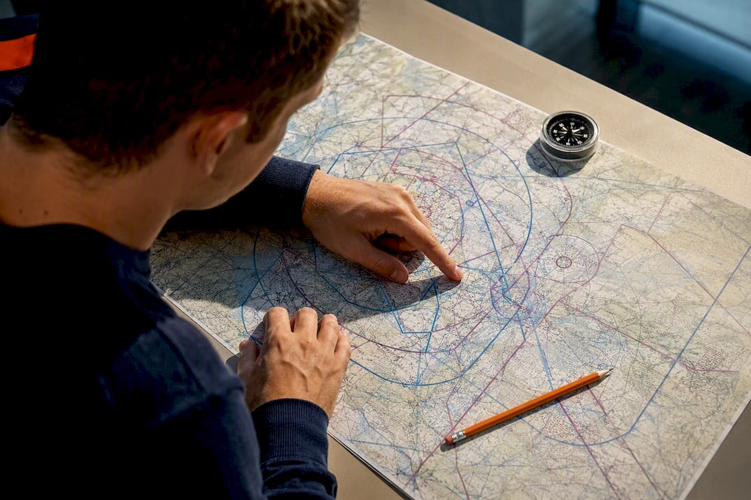
Sectional charts use line style and color to tell you where one class ends and another begins, and learning to read them fluently takes real practice, not a single study session. Class B boundaries are drawn as solid blue lines. Class C uses solid magenta lines. Class D shows up as dashed blue lines. Class E surface areas that don’t fit the standard pattern get dashed magenta lines, and where Class E starts at 700 feet AGL rather than 1,200, you’ll see a shaded magenta gradient instead of a hard line.
Numbers inside the boundary tell you the ceiling and floor for that segment, usually written as a fraction, with the top number as the ceiling and the bottom as the floor, both typically in hundreds of feet MSL unless a note says otherwise. A “SFC” abbreviation means the airspace floor sits at ground level for that sector.
A short list of habits worth building early:
- Always check the chart’s legend panel before you assume you know what a line color means. Legends have printed conventions that change slightly between chart types.
- Look for extension callouts near towered airports. They often add oddly-shaped Class D or E bulges you’d otherwise miss.
- Cross-reference altitude figures against MSL, not AGL, unless the chart explicitly states AGL for that segment.
Pro Tip: Print a blank sectional excerpt and quiz yourself on class boundaries with the legend covered up. Recognizing line patterns without hints is the actual skill your checkride examiner will test, not just naming the colors.
When Airspace Classes Overlap: Which Rule Wins
Airspace designations are technically mutually exclusive, meaning a given point in space belongs to exactly one class at a time. But special-use areas and layered structures can make it feel like several rules apply at once. The resolution is simple: the more restrictive designation always controls your operation.
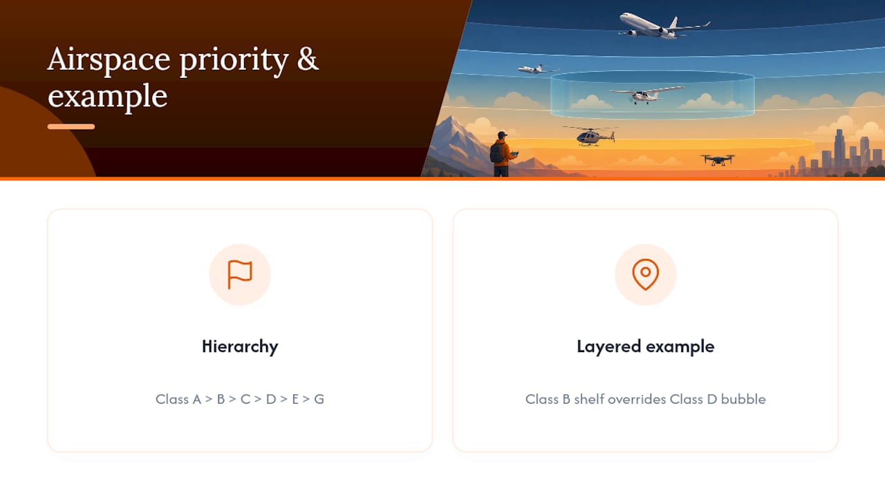
Think of it as a strict pecking order: Class A outranks B, which outranks C, then D, then E, then G. If a Class B shelf sits directly above a Class D bubble around a smaller field, the Class B rules govern that airspace the moment you climb into it, even though the Class D tower is still active below.
The rule of thumb worth keeping in your head on a busy flight: when in doubt about which set of rules applies, default to the stricter one and get on the radio. Controllers would rather field an unnecessary call than sort out an incursion after the fact.
A Preflight and In-Flight Checklist for Student Pilots
Good airspace discipline starts on the ground, not in the cockpit. Build these habits now, and they become automatic well before your checkride.
Before you ever start the engine:
- Pull the current sectional or terminal chart for your route and trace every class boundary you’ll cross, not just the destination.
- Check NOTAMs and TFRs for your entire route, including altitudes you don’t plan to use, since restrictions can shift with little warning.
- Confirm your transponder and ADS-B Out are functioning if your route touches Class B, C, or the airspace above most Class D and C fields.
- File an IFR flight plan if any portion of your route touches Class A or you’re flying in weather below VFR minimums.
Once you’re airborne, establish communication before you reach a controlled boundary, not the second you cross it. A radio call made thirty seconds too late still counts as too late if the controller hasn’t acknowledged you yet. Keep your calls simple: aircraft type and call sign, position, altitude, and request. If you’re ever unsure whether you’re cleared to proceed, ask directly rather than guessing.
Pro Tip: If you realize you’ve drifted into controlled airspace without clearance, the immediate move is to contact ATC on the frequency for that airspace, state your position and altitude plainly, and follow instructions. Reporting it yourself, promptly and honestly, goes a long way with the FAA compared to getting caught after the fact.
Applying Airspace Rules as a Working Drone Pilot
Manned aircraft rules and drone airspace rules overlap more than most new UAS operators expect, and the practical workflow for checking airspace before a flight looks similar across both worlds. A drone pilot planning a job near a Class D field still needs to know the boundary, the floor altitude, and whether authorization is required before launch.
Dronable’s SkyScore™ tool checks the airspace class and any active restrictions at a job site before you fly, which turns a multi-step manual chart review into a single lookup. Pairing that check with a digital credential system that stores your certifications and authorizations means you can show proof of compliance to a client or an inspector on the spot rather than digging through paperwork.
The workflow that actually holds up under scrutiny looks like this:
- Check the site’s airspace class and any restricted or controlled firing areas before accepting the job.
- Request LAANC or manual authorization through the appropriate channel if the site sits in controlled airspace near an airport.
- Log the flight automatically, including altitude and location, so your record matches what you’d need if a client or the FAA asks questions later.
- Store certifications and waivers in one place instead of scattered across email threads and paper files.
None of this replaces knowing the rules yourself. It just removes the friction of applying them correctly every single time.
Study Priorities That Actually Get You Checkride-Ready
Most students try to memorize chart colors before they understand what the colors are protecting against, and that order is backwards. Learn the vertical limits and communication requirements for each class first. Once you can recite that Class B needs a clearance, Class C and D need two-way radio contact, and Class E usually needs nothing at all, the chart symbology clicks into place because you already know what you’re looking for.
I’d tell any student to spend the first study session with a blank chart and no legend, just naming what each line probably means based on shape and location relative to a known towered airport. Then check answers against the legend. That order forces you to reason through the system instead of pattern-matching colors you half remember.
The pecking order matters more than any single class in isolation. Examiners love asking what happens when a Class B shelf sits over a Class D field, precisely because it tests whether you understand hierarchy or just memorized six definitions in isolation. Get comfortable with that overlap logic early, and the individual class rules stop feeling like six separate things to memorize and start feeling like one system with predictable exceptions.
Checking Airspace Without the Guesswork
Some platforms give drone pilots a faster way to confirm what class of airspace they’re flying into and what authorization it requires, instead of cross-referencing a sectional, a NOTAM feed, and separate authorization portals for every job. Tools can flag controlled airspace and restrictions for a specific location before launch, and digital credential stores keep certifications and waivers in one place you can pull up instantly for a client.

None of this replaces your own knowledge of the classes covered above. A tool can flag that you’re near Class D airspace, but you still need to know what a part-time tower schedule means for your flight. What these platforms remove is the busywork: switching between multiple apps to confirm one flight is legal to fly. The Operations Manual tool helps formalize those checks into a repeatable procedure for commercial jobs, and the Academy resources back up the airspace fundamentals from this article with structured certification prep.
If you’re prepping for a checkride or building a drone operation that needs to hold up to client scrutiny, check out Flydronable’s full toolset and see which features fit your current flying.
Sources
Recommended
Explore Dronable Tools
Deepen Your Knowledge
Get step-by-step video courses in the Dronable Academy — FAA Part 107, EASA, real estate drone photography, and more.
Browse CoursesFree: How to Start a Drone Business
The complete step-by-step guide to turning your passion for flying into a profitable drone business — completely free.
- 10 steps to launching your drone business
- 51 proven drone business ideas
- How to get FAA certified (Part 107)
- Pricing, clients & recurring income
Join the Dronable Newsletter
Get drone tips, new articles, and exclusive deals straight to your inbox. No spam, unsubscribe anytime.


