UAS Facility Maps for Drone Pilots: Comply Fast and Automate Map Checks
UAS Facility Maps for Drone Pilots: Comply Fast and Automate Map Checks
UAS Facility Maps show the maximum altitude, in feet above ground level, that FAA processors may authorize for Part 107 operations at a given location. Use that mapped altitude when you submit a request through LAANC or FAADroneZone. The map itself grants nothing. It only tells you what number gives your request the best chance of fast approval.
- The altitude values on UAS Facility Maps are set by local air traffic controllers based on real aircraft traffic patterns, not random formulas.
- When planning a flight, pilots must use the lowest grid cell altitude touched by their operation for accurate request submissions.
- Automatic FAA approval applies only if the request is at or below the mapped altitude, which should be rounded down to avoid rejection or delays.
- The maps update every 56 days and cover controlled airspace mainly near airports, with terrain affecting actual AGL limits.
- Cross-checking NOTAMs, TFRs, and current operational data is essential, as airspace restrictions can change frequently beyond what the maps show.
Flydronable
Simplify Your Airspace Checks
Dronable brings airspace safety and flight operations tools together, helping pilots manage complex drone work from one unified workspace.
Table of Contents
- What Do UAS Facility Maps Actually Show?
- How to Use Facility Maps When Planning a Flight and Requesting Authorization
- Where to Access and Download Official Map Data
- Grid Resolution, Scale, and the 56-Day Update Cycle
- Common Mistakes That Delay or Kill Authorization Requests
- How Integrated Tools Can Simplify the Compliance Side
- Why Facility Maps Belong in Every Preflight Checklist
- A Faster Path From Map Data to a Submitted Request
- Sources
- FAQ
What Do UAS Facility Maps Actually Show?
A UAS Facility Map is a grid overlay on controlled airspace near an airport. Each cell in the grid carries a number that guides FAA processors on a suggested maximum altitude for automatic approval without additional review. The maps cover Class B, C, D, and surface-area E airspace, which means they apply almost everywhere flying near a towered or radar-served airport gets complicated.
Every altitude on the grid is measured in AGL, not MSL. That distinction matters because two grid cells a mile apart can sit at very different elevations, so the same 100 foot AGL limit represents different absolute altitudes depending on the terrain underneath.
The numbers were not pulled from a formula. Local air traffic controllers and airport staff set them based on actual manned aircraft approach paths, departure corridors, and helicopter operations at that facility. That is worth remembering when a grid cell shows an unusually low number right next to a much higher one. It usually reflects a real traffic pattern, not an arbitrary line.
A few things to keep in mind when you first pull up a map for your site:
- Grid values represent the ceiling for automatic processing, not a floor or a recommendation for your mission.
- A “0” value means the FAA does not intend to authorize any altitude in that cell without extra coordination.
- Coverage stops outside controlled airspace. Uncontrolled Class G airspace won’t show a UAS Facility Map grid at all.
How to Use Facility Maps When Planning a Flight and Requesting Authorization
Reading the map correctly is only half the job. The other half is turning that number into an approved authorization before you launch.
- Locate your operating area on the FAA’s UAS Facility Map viewer using an address or latitude and longitude coordinates.
- Identify every grid cell your flight touches. Most missions cross more than one cell, especially for linear surveys or perimeter mapping.
- Take the lowest altitude among those cells. The FAA’s decision flow chart is explicit on this point: when your operation spans multiple grids, the lowest number governs your request.
- Submit through LAANC if the facility supports automated approval at or below that altitude, or through FAADroneZone if LAANC isn’t available or you need a manual review.
- Expect facility coordination if you request above the mapped altitude. That request still goes to a human controller for a safety analysis, and turnaround takes longer.
A complete request should include your AGL altitude, precise coordinates, the operations window (date and time), a working contact phone number, and a brief note on safety mitigations like observers or geofencing. Requesting the exact mapped altitude is the single fastest lever you have for cutting processing time.
Pro Tip: Round down, not up. If your grid cells show 100 and 150 feet, plan and request 100. Rounding up “just to be safe” is the most common reason authorization requests bounce back for manual review.
Where to Access and Download Official Map Data
For a quick check before a job, the FAA’s interactive UAS Facility Maps landing page lets you zoom into an address and read grid values directly. That’s fine for one-off site checks.
For anything you plan to automate, feed into mission-planning software, or archive for compliance records, go to the FAA UAS Data Delivery System (UDDS) instead. It’s the primary source for raw datasets:
- KML files for viewing grids in Google Earth or most flight-planning apps.
- GeoJSON and CSV for importing grid boundaries and altitude values into custom tools or spreadsheets.
- Shapefile exports for GIS software like ArcGIS or QGIS.
Some state GIS portals mirror this same FAA dataset. Maryland’s iMap, for example, hosts a UAS Facility Map layer that’s useful as a reference for how agencies integrate the federal data locally. Whichever source you use, note the map’s effective date and keep it with your flight records. If a facility’s numbers change between the time you checked and the time you flew, that date is your proof of what you actually saw.
Grid Resolution, Scale, and the 56-Day Update Cycle
The grid itself has a fixed size: 30 seconds of latitude by 30 seconds of longitude, which corresponds approximately to a quarter of a square mile per cell in much of the contiguous United States. Near the poles that math shifts slightly because longitude lines converge, but for nearly every operator in the lower 48, that acreage figure is the one to remember.
Two details that consistently trip up new Part 107 operators:
- Altitude is always AGL. If you’re launching from a hillside or a rooftop, calculate your actual height above the ground beneath your flight path, not above your launch point.
- Maps update on a 56-day cycle, tied to the same aeronautical chart cycle pilots already use for sectional charts.
A 160-acre grid cell can still contain wildly different terrain. A single cell might cover a flat parking lot on one edge and a 200-foot ridge on the other. The mapped altitude doesn’t adjust for that. You do.
Common Mistakes That Delay or Kill Authorization Requests
Most rejected or delayed requests trace back to a handful of avoidable habits.
- Treating the map as the authorization. It’s a planning reference. You still must submit a request through LAANC or FAADroneZone every time.
- Averaging grid altitudes instead of using the lowest one. If your flight touches a 200 foot cell and a 75 foot cell, your request needs to reflect 75, not 137.
- Skipping NOTAMs and FRIA/TFR layers. These sit alongside the facility map data in UDDS and can restrict airspace the grid altitude alone won’t show you.
- Requesting a round number that ignores the actual grid value, which almost always triggers manual review instead of automatic approval.
Pro Tip: Screenshot the map with its effective date visible, save it with your mission file, and put a callback number in every LAANC or FAADroneZone request. Reviewers who can reach you by phone tend to resolve ambiguous requests faster than ones that sit in a queue waiting for an email reply.
If your job requires precise ground elevation data to nail down true AGL, a topographic survey of the site removes the guesswork that trips up so many authorization requests near uneven terrain.
How Integrated Tools Can Simplify the Compliance Side
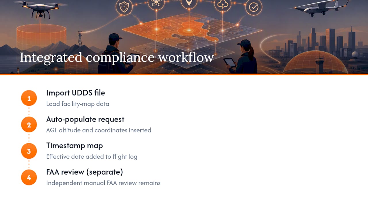
Reading grids by hand for every job gets tedious fast, especially for crews running multiple sites a week. Platforms built for drone operations can import UDDS files directly, auto-populate the AGL altitude and coordinates into an authorization request, and timestamp the map’s effective date automatically in your flight log. That doesn’t replace the FAA’s review. It just removes the manual re-entry that causes typos and mismatched grid values in the first place.
Why Facility Maps Belong in Every Preflight Checklist
Skipping the map check is how pilots end up requesting altitudes that trigger manual review for no good reason. Checking it takes thirty seconds and tells you exactly what number gives your request a shot at automatic approval.
That said, the map is only step one. Cross-check it against LAANC or FAADroneZone availability and current NOTAMs before every flight, not just the ones near airports you’ve never worked before. Airspace status changes more often than most pilots assume, and the facility grid you memorized last month may not be the one governing your airspace today.
Automating that verification, rather than relying on memory or a bookmarked PDF, is where most operators eventually land once they’re flying regularly enough that manual checks start eating real time.
A Faster Path From Map Data to a Submitted Request
Reading grids, cross checking NOTAMs, and rebuilding the same authorization request every week is manageable at low volume and genuinely tedious once you’re flying several sites a month. Dronable gives operators a way to skip the manual re-entry between the FAA’s data and the actual submission.

The platform’s flight logging can automatically record the map effective date alongside your mission file, so you have a timestamped answer if a request ever gets questioned later. None of this replaces FAA approval. LAANC and FAADroneZone remain the systems that grant authorization. What Dronable removes is the busywork around getting a clean request in front of them the first time. Pilots who want to see how the Operations Manual tool handles checklists and compliance records can walk through it directly, or explore the full tool set to see what fits a given crew’s workflow.
Sources
- UAS Facility Maps FAQ — Federal Aviation Administration
- FAA UAS Data Delivery System
- FAA UAS Facility Map Data — Maryland iMap (example mirror)
FAQ
Where Can I Find FAA UAS Facility Maps?
The official interactive viewer sits on the FAA’s UAS Facility Maps page, and raw datasets for download live on the UAS Data Delivery System.
What Is a UAS Facility Map Used For?
It shows the maximum AGL altitude the FAA may authorize for Part 107 operations in a given grid cell, helping pilots choose an altitude likely to clear LAANC or FAADroneZone review quickly.
Where Can I Find a Map of FAA Drone Restrictions?
UAS Facility Maps cover altitude limits near controlled airspace, while NOTAMs, FRIA boundaries, and temporary flight restrictions are layered separately on the UDDS portal and should be checked alongside the facility map before every flight.
Does the FAA Restrict Drone Flights Near Certain Airports or Cities?
Restrictions apply airspace by airspace rather than by city, tied to specific Class B, C, D, or surface Class E airspace around individual airports rather than entire metro areas; check the facility map and current NOTAMs for your exact operating location.
Does a Low Grid Altitude Mean I Can’t Fly There?
No. A low or zero grid value means automatic approval isn’t available at that altitude, but you can still submit a request through FAADroneZone for manual review and facility coordination.
Recommended
Explore Dronable Tools
Deepen Your Knowledge
Get step-by-step video courses in the Dronable Academy — FAA Part 107, EASA, real estate drone photography, and more.
Browse CoursesFree: How to Start a Drone Business
The complete step-by-step guide to turning your passion for flying into a profitable drone business — completely free.
- 10 steps to launching your drone business
- 51 proven drone business ideas
- How to get FAA certified (Part 107)
- Pricing, clients & recurring income
Join the Dronable Newsletter
Get drone tips, new articles, and exclusive deals straight to your inbox. No spam, unsubscribe anytime.


